PORTFOLIO
GIS-4043 Introduction to GIS
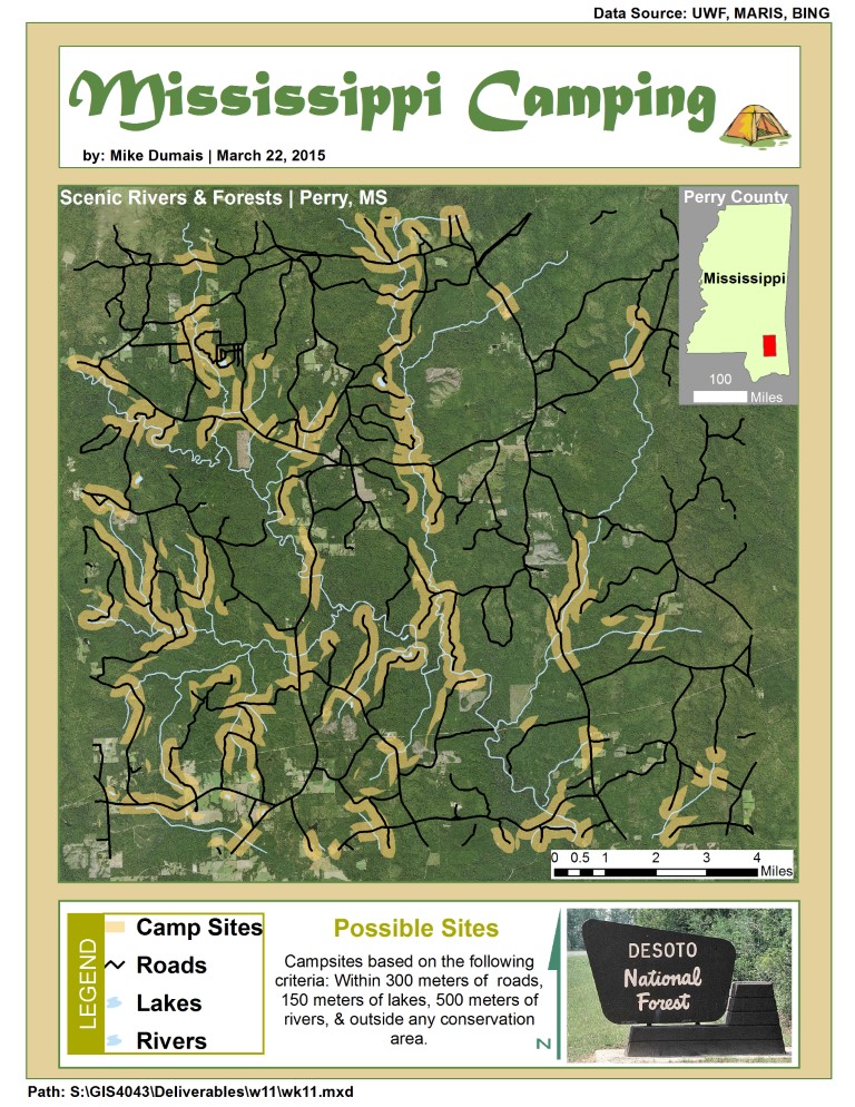
This map involved some spatial analysis where I examined locations, attributes, and relationships of features in spatial data through overlay and other analytical techniques to obtain knowledge of campsites near other features (roads, lakes, and rivers) that might be helpful when selecting a campsite. Proximity Analysis answers questions like what campsite features are near other features, such as streets, lakes, and rivers. The outcome of proximity analysis is the generation of new information as the result of taking one or more actions on a set of features described by some criteria. I put this into action when obtaining useful camping information. GIS overlay tools combine features and attributes from multiple layers to create new information. Both the geometries of the features and the attributes of those features are carried through the overlay process.
gis analysis
GIS 3015 Cartographic Skills
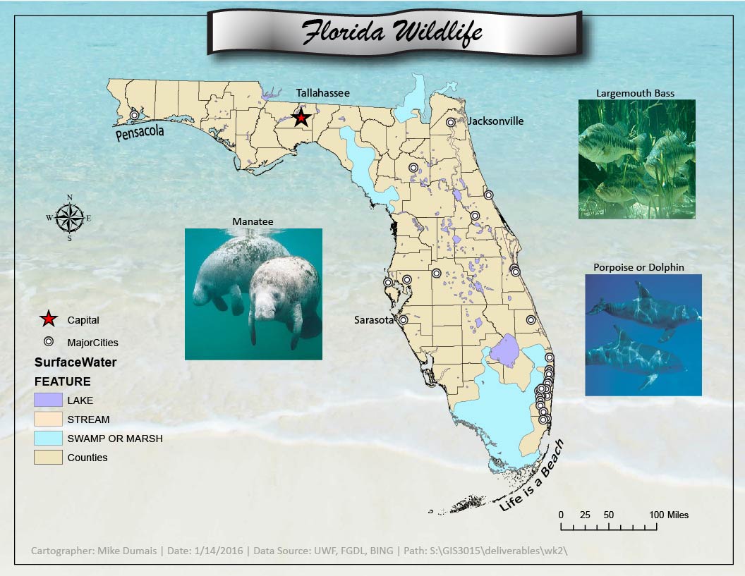
In this class, I learned to graphically communicate via artistry, symbols, fonts (typography), and balancing all primary & secondary (figure-ground) objects in a pleasing way based on the map purpose and intended audience. In this map example, I applied a few design principles (simplicity, context appropriateness, and pleasing appearance) and several aspects of map composition (visual balance, focus of attention), which is the arangement or organizaition of map elements.
cartography
GIS 4102 GIS Programming
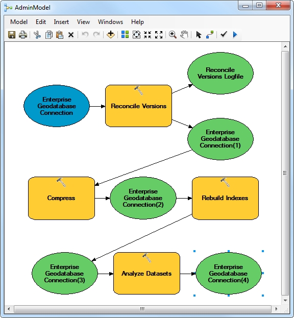
I've used this model for many years as an Enterprise GIS GeoDatabase administrator. It's an Esri good practice for maintaining a geodatabase. As a geodatabase is edited over time, the adds and deletes tables increase in size which can negatively impact database performance. I've also exported this model as a Python script and executed it as a nightly task by creating a Windows scheduled task. Automating various geoprocessing tools in a script during available network maintenance windows will help ensure your GIS customers have a responsive experience.
programming - python - arcade
GIS-4035 Remote Sensing & Photo Interpretation
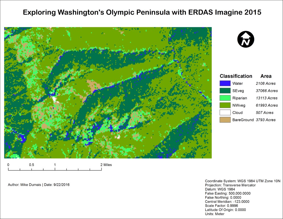
This statis map deals with Remote Sensing. It is the result of learning the basics of ERDAS Imagine and properties of Electromagnetic Radiation (EMR), the source of energy recorded and analyzed in all types of remote sensing. ArcMap 10.3 was used to display the output of preprocessing (subset) an advanced Very High Resolution Radiometer (AVHRR) satellite image using ERDAS.
visual image interpretation
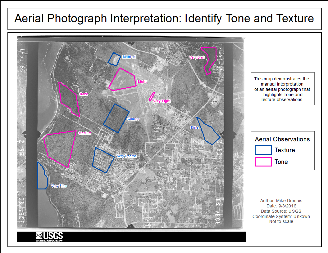
GIS-4035 Remote Sensing & Photo Interpretation
This statis map deals with Photo Interpretaton. The image reminds me how-to use various recognition elements to visually interpret aerial photographs by using the tone and texture of aerial photographs. Tone describes the brightness or darkness of an area. Texture deals with how smooth or rough the surface appears.
visual image interpretation
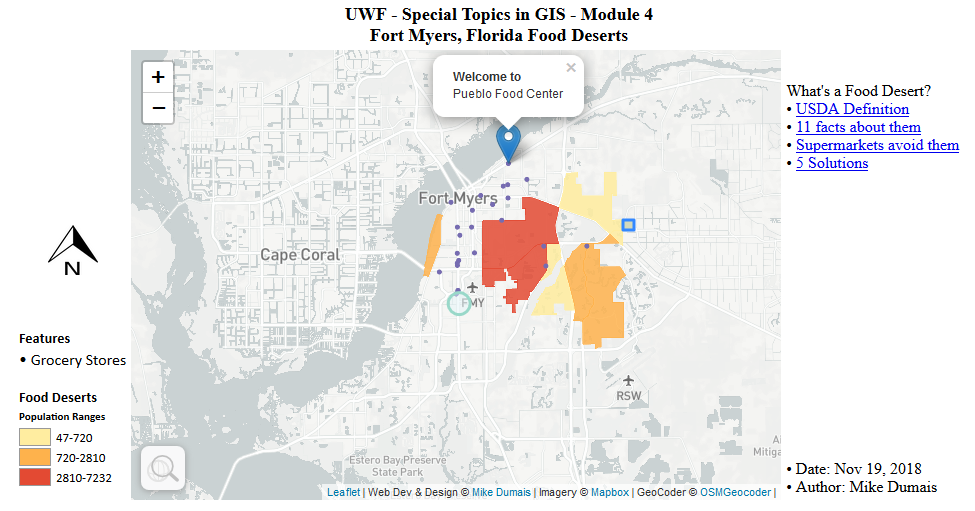
GIS-4930 Special Topics in GIS
This is an example of a web map that was created with the following Open Source software:QGIS , leaflet javascript library, and Mapbox. It can be viewed here.
open source software
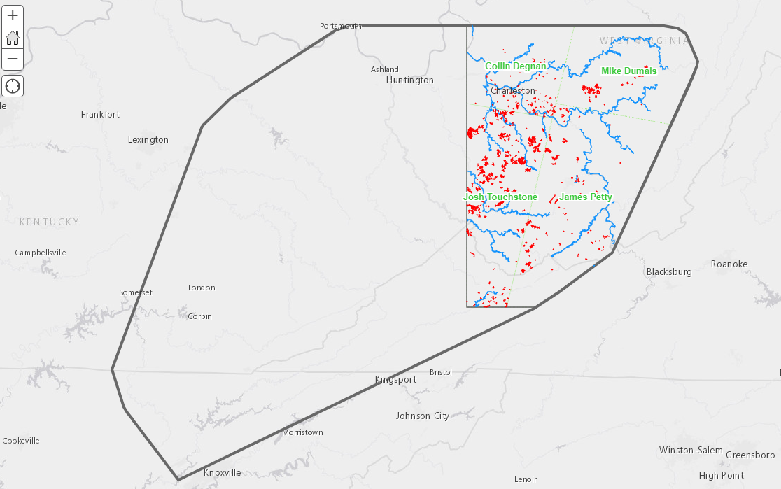
GIS-4930 Special Topics in GIS
This web map is the result of a four students working together to complete a group Mountaintop Removal project that was created with Esri Online. Students started with 4 overlapping Landsat images; and this web-map is the outcome. I'm a group member and labels will appear when you zoom in on the map.
esri online web map
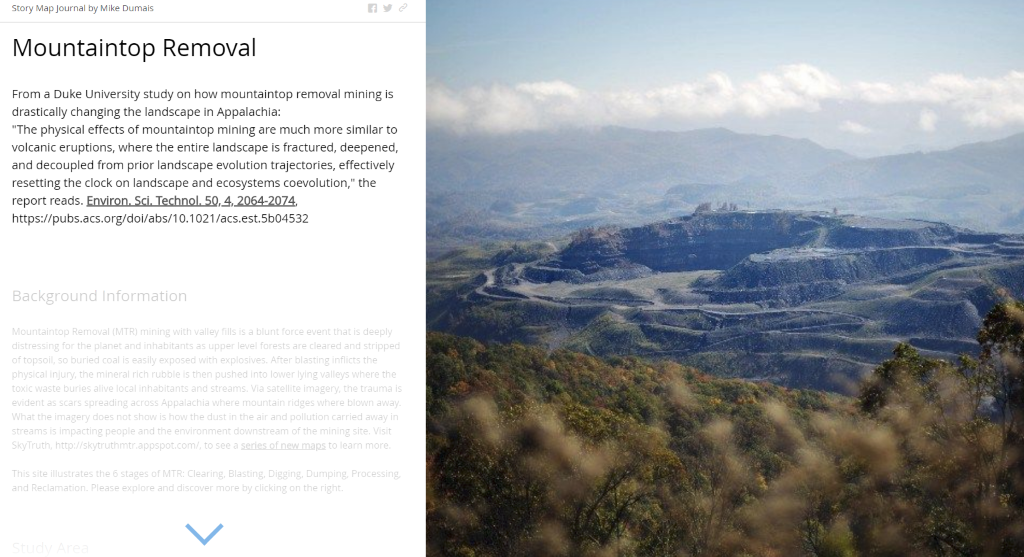
GIS-4930 Special Topics in GIS
This is a story map journal is made up of different types of slides (graphic/image, map, web map, video, etc). Each slide is a navigational component that has two parts: a descriptive part and visual part, which is the main visual part of the slide component. It's a great way to capture you map user's attention.
story map journal
GIS-4048 Applications in GIS
This course provided a balance between the "how-to" of using ArcGIS Pro and the "why" of GIS by explaining the roles GIS technology plays in analyzing local, regional, and international problems. Major course components included computer representation of geographic information, the construction of GIS databases, spatial analysis with GIS, application areas of GIS, and management issues concerning GIS.
Urban Planning projects

GIS-4944 Internship
During this semester I continued to apply learned GIS skills at work, focus on learning ArcGIS Pro, and build a web-enabled version of both a profile and resume. I experimented with various types of templates that I discovered on the internet. This website that you are currently viewing is my work-in-process profile, which contains links to a web version of my resume and a downloadable version of my resume. Of all the templates I created, this one works the best for a shared low-budget student hosting account through sitegrounding.
gis - html - css - js in action
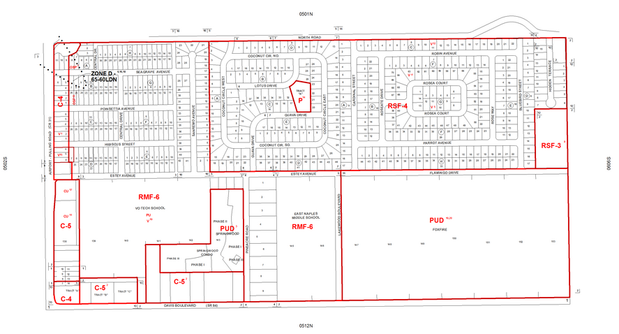
(Prototype) - Zoning Map
During my internship, I also finished a prototype web application to assist plans reviewers examine both approved zoning and plat recordings based on the assets created in the GIS department by several existing internal workflows. I built the app template with HTML, CSS, and JavaScript. ArcMap was used to create the map exports that the template app displays for various internal and external business processes.
gis - html - css - js in action